Loading...
All Campgrounds
7577 results
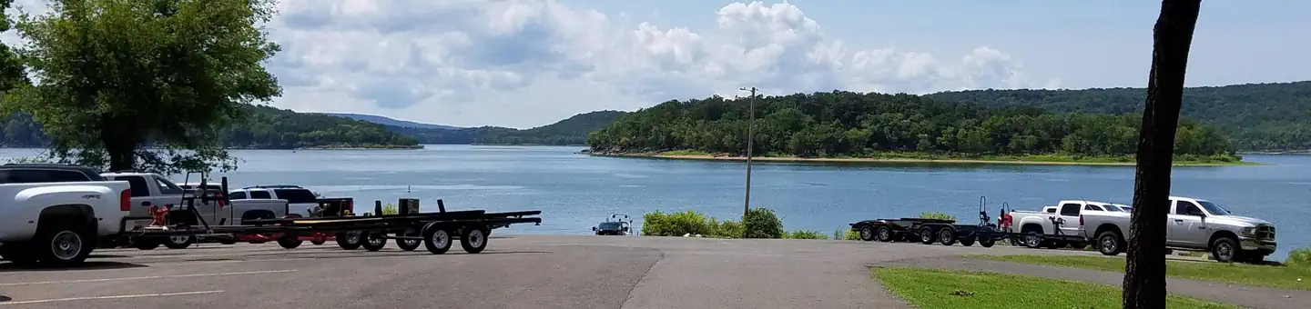
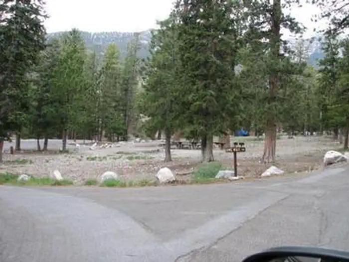
PETTIT BAY
Tenkiller Ferry Lake, OK
☆☆☆☆☆0.0(0 reviews)
lake89 sites
Overview Pettit Bay Campground on Tenkiller Ferry Lake is a recreational paradise for visitors looking for a well-kept waterfront facility, which offers convenient access for boating, swimming and wildlife viewing. It is located near the historic town of Tahlequah and attracts many campers who return year after year.Recreation Boating, fishing, water skiing, hiking, and swimming are some of the activities enjoyed by visitors. Prevailing winds and secluded coves create an ideal environment for sailing. Scuba divers enjoy the lake's clear waters and high visibility. Fishing is good for black bass, white bass, striped bass, crappie and catfish. The trout stream below the dam is one of only two year-round trout fisheries in Oklahoma, and is regularly stocked with rainbow trout. Hunting is also permitted in parts of the lake area, in accordance with federal and state laws.Facilities The campground has sites with electric hookups, and some sites are non-electric. The park has flush toilets, hot showers, water hydrants, a swim beach, playground, dump station, and boat ramps with courtesy docks. A marina with concessions is adjacent to the campground. Of the ten marinas with concessions located on the lake, most offer boat and jet-ski rentals, and several have floating restaurants.Natural Features Tenkiller Ferry Lake is often referred to as "Oklahoma's clear water paradise." The 12,500 acre lake is sourced by the Illinois River and the Baron Fork, which are both designated as Oklahoma Scenic Rivers. It is nestled in the foothills of the Ozark Mountains in the northeastern part of the state. This area, known as Green Country, is surrounded by dense oak-hickory forests, tall bluffs, and rolling hills. The lake has 130 miles of shoreline with plenty of wildlife such as deer and turkey. It serves as one of the flyways of migratory birds, including bald eagles, common loons, and white pelicans. Nearby Attractions Visit the Tenkiller State Park for its nature center and scuba diving park, the Sequoyah National Wildlife Refuge near Vian, or the historic city of Tahlequah - the capital of the Cherokee Nation. The scenic upper Illinois River near Tahlequah is great for canoeing and rafting, and the lower Illinois River near Gore offers prime trout fishing.
Lynx Pass Campground
Medicine Bow-Routt NFs & Thunder Basin NG, CO
☆☆☆☆☆0.0(0 reviews)
lake0 sites
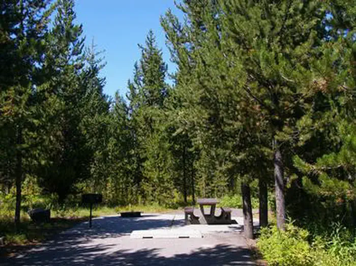
DESCRIPTION: Located in the Gore Pass area on the Routt National Forest. Lynx Pass campground is a small campground hosting 11 sites and can be found on Forest Service Road 270 between the towns of Kremmling, CO and Yampa, CO (off HWY 134)The Lynx Pass Campground and surrounding area offers outdoor enthusiasts an opportunity to enjoy the simple pleasure of being outside. The campground is surrounded in lodgepole pine offering mostly shade, with a secluded, natural and primitive feel and can accommodate tents, campers, and trailers. This campground is popular for big game hunting in the fall. Max Length for campers/trailers: 18 feet Amenities:Picnic table at each siteFire grate at each sitePotable water Trash service1 vault toiletSeveral trailheads nearbyElevation & Weather: At 8,989 ft, campers can expect cold evenings and cool mornings even during the warm summer months and snow-covered sites into the 2nd week of June. Recreation Opportunities at Lynx Pass:Mountain biking: Tepee Creek Trail #1173 , Morrison Divide (Muddy Slide) Trail #1174 E-Biking (allowed on motorized trails and roads ONLY): Morrison Divide (Muddy Slide) Trail #1174 ATV Trail: Morrison Divide (Muddy Slide) Trail #1174 (usda.gov) PLEASE NOTE: Trail is narrow and ALL ATVS MUST BE UNDER 50” in width. Violators will be fined. ATV's MUST BE TRAILERED FROM THE CAMPGROUND TO THE TRAILHEAD.Hiking trails (30-minute drive to the Sarvis Creek Wilderness Area near Stagecoach Reservoir): Sarvis Creek Wilderness Fishing is popular at Lagunita Lake just a short walk from the campground.Other Recreation Areas Nearby:3.5 miles - Rock Creek Recreation Area 6 miles - Blacktail Creek CampgroundRed Dirt Reservoir and dispersed camping recreation areaClosest Towns:Toponas, COYampa, COKremmling, CO Directions: Lynx Pass Campground can be accessed on its northern end via County Road 16 from Stagecoach State Park/Oak Creek, and from the southern end via State Highway 134. State Highway 134 can be accessed from either HWY 40 (Kremmling, CO) or from Steamboat Springs or Yampa, CO via HWY 131.
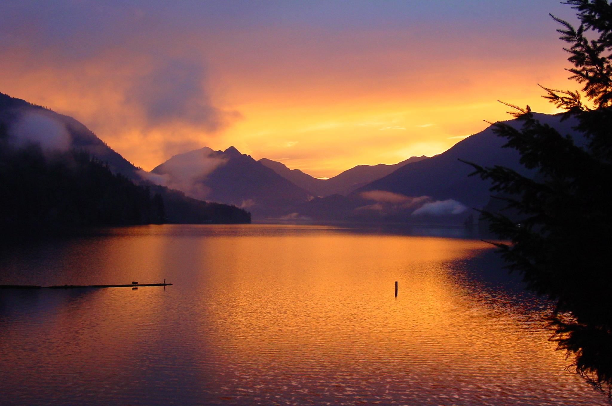
Fairholme Campground
Olympic National Park
☆☆☆☆☆0.0(0 reviews)
creek84 sites
Overview The reservation season the 2026 summer season for Fairholme Campground is May 15, 2026 - September 29, 2026. Important information about booking windows: To better serve visitors, Fairholme Campground will be releasing campsites in a series of three staggered block releases by loop. These block releases will be 6 months in advance, two weeks in advance, and 4 days in advance. • B loop campsites and the majority of the walk-to sites will be available for reservation 6 months in advance. • C loop campsites and most of the remaining walk-to sites will be available for reservations 2 weeks in advance. • A loop campsites and walk-to site 85 will be available for reservations 4 days in advance. The campground may open on a first-come, first serve basis during the spring depending on weather before the reservation season. Fairholme Campground is located next to Lake Crescent on the north side of the Olympic Peninsula in Olympic National Park. The campground sits in an old-growth forest surrounded by steep mountains. Fairholme Campground features walk-in lakefront campsites and several drive-in campsites that provide views of Lake Crescent. The campground is large and set amidst a peaceful forest that thrives on the region's high annual rainfall. Rain or shine, it is one of the most visited areas of the park.Recreation Numerous day hiking opportunities are available near the Lake Crescent area. Please follow the link to Olympic NPS page for more information - Lake Crescent Area Brochure - https://www.nps.gov/olym/planyourvisit/lake-crescent-area-brochure.htm Paddling and boating opportunities are available within minutes from the campground. Lake Crescent boat launch is located adjacent to the campground. Please follow the link to learn more - Boating - https://www.nps.gov/olym/planyourvisit/boating.htm Fairholme Olympic Discovery Trailhead is located about 2 miles west of Fairholme Campground on US Highway 101. Bicycling, road cycling, and hiking are available at this access point. Please follow the link to learn more - https://www.fs.usda.gov/recarea/olympic/recreation/bicycling/recarea/?recid=80688&actid=26 Facilities Fairholme Campground is a large facility with 84 campsites, including walk-in lakeside campsites and one ADA accessible site. Each site has a campfire ring and picnic table. Food storage lockers are provided in some, but not all campsites. Drinking water is available at each bathroom and water spickets are also located along the trails to the walk-in campsites. There are no RV hookups at this facility, but a RV water fill station and RV septic dump station are located next to the campground where the boat launch is. Payment is required for each use of the RV septic dump station. The nearest gas station is located 17 miles west on US Highway 101 at the junction with SR 113. The nearest shower facility is Bogachiel State Park (35 miles one way) located off US Highway 101. Payment is required for use of shower facilities. Campers can purchase firewood at Fairholme General Store, Lake Crescent Lodge, and Log Cabin Resort. Natural Features Lake Crescent, a cold, clear, glacially carved lake, owes its existence to ice. Its azure depths, which plummet to 624 feet, were gouged by huge ice sheets thousands of years ago. As the ice retreated, it left behind a steep valley that filled with the clear blue waters of Lake Crescent. Nearby Attractions Olympic National Park has much to explore, including temperate rain forests, ocean shores, sub-alpine mountains, lakes and more. The towns of Port Angeles, Forks, and Beaver are within a 30 to 60-minute drive. Fairholme Campground is along the shores of Lake Crescent, which is a big attraction for visitors to the park. Additionally, access to the Sol Duc Valley, with its popular Sol Duc Falls trail and Sol Duc Hotsprings Resort nearby. A moderate drive from the campground also provides access to the Marymere Falls and Mount Storm King trails. Fairholme Campground is a good base camp to explore Olympic National Park, as it is located between Port Angeles (Hurricane Ridge) and popular western locations such as Rialto Beach, Hoh Rainforest, and Kalaloch/Ruby Beach. Contact Info For facility specific information, please call (360) 327-3250.Charges & Cancellations A $10.00 service fee will apply if you modify your reservation or change your stay dates. Cancelling your reservation prior to 11:59 pm Eastern Time two nights before your stay will incur a $10 cancellation fee. Camping reservations cancelled the day before and day of arrival incur a $10 cancellation fee and forfeit the first night's use fee If you need to cancel or modify your reservation after 12:00 am Eastern Time on the day of arrival you must contact campground staff. Recreation.gov Rules and Reservation Policies
RIVERSIDE (ID - TARGHEE)
Caribou-Targhee National Forest, ID
☆☆☆☆☆0.0(0 reviews)
lake58 sites
Overview Riverside Campground is on the banks of the Henry's Fork of the Snake River, just 15 miles north of Ashton, Idaho. Beautiful Island Park is nearby, where visitors enjoy boating, fishing and exploring local trails. Please click here for further information about the facility and recreation opportunities in the area.Recreation Henry's Fork has great fly-fishing for rainbow and brook trout. Tubing, canoeing, kayaking and rafting are also popular activities on the river.Facilities The campground offers one group site that can accommodate up to 40 people. Several single family sites are also available, each equipped with a picnic table, campfire ring and grill. Vault toilets, drinking water and trash collection are provided but there is no electricity. Firewood is available for purchase from the host. Gas and groceries are 8 miles away.Natural Features The campground is situated along the Henry's Fork at an elevation of 6,200 feet. Lodgepole pines provide partial shade and aspens dot the landscape. Summer wildflowers are abundant. A variety of wildlife, including moose and deer, is frequently spotted throughout the area. Nearby Attractions Island Park has outdoor activities for visitors of all ages. Hundreds of miles of hiking, biking, horseback riding and ATV trails crisscross the area. Island Park Reservoir and Henry's Lake are nearby, with boat ramps, fish cleaning stations, boating, water skiing and fishing. Yellowstone and Grand Teton National Parks are close enough for a day trip. Both parks offer hiking and fishing in breathtaking natural settings.
White Bird Gravel Pit Recreation Site
ID
☆☆☆☆☆0.0(0 reviews)
lake0 sites
This day use site on the Lower Salmon is a frequent put-in spot for floating the Lower Salmon River from White Bird to Pine Bar or Heller Bar. The site is largely undeveloped, but has easy access to the Salmon River. BLM recreation sites attached to this stretch of river are Island Bar, Lucile, Old Lucile, Shorts Bar, Slate Creek, Skookumchuck, Hammer Creek and Pine Bar. Be sure to check those sites for more information and amenities for boat ramps or camping. For river maps, authorized outfitters and shuttle services, see the links below.
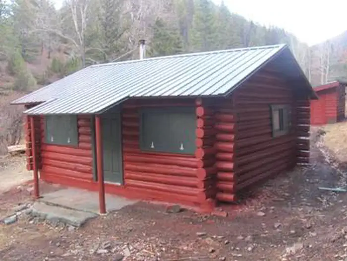
MILLER CABIN
Helena-Lewis and Clark National Forest, MT
☆☆☆☆☆0.0(0 reviews)
1 sites
Overview The Miller Creek Cabin is located in the Townsend Ranger District and rests at the intersection of the Confederate Gulch Road (FS Road 287) and the Blacktail Road (FS Road 4171), surrounded by scattered forest in the Big Belt Mountains in west-central Montana. The cabin is accessible by high-clearance vehicle, but requires over-the-snow vehicle travel during winter months. Please use caution when accessing Miller cabin in the winter months, winter access will vary based on snow conditions. Do not count on wheeled vehicle access from November through April. You can get to Miller cabin in the winter months with snowmobile or cross country skiing. It is not recommended driving full size vehicle to the site during this time period. Recreation During the summer months, enjoy a hike on local trails that will take you to high mountain lakes. During the fall, the cabin offers a wide array of recreation opportunities including hiking, hunting and off-highway vehicle access. The winter months provide for cross-country skiing and snowmobile opportunities.Facilities This is a two room log cabin that has been completely remodeled. In addition to the cabin there is a wood shed and new outhouse facility. Miller is a rustic log cabin furnished with two sets of bunk beds, kitchen hutch and table with four chairs. Pots and pans as well as dishes and some cleaning supplies are available for use. A two-burner propane camp cook stove and two lanterns are provided. Guests will need to provide their own fuel for the cook stove and lanterns. The stove and lantern require pre-filled propane cylinders which screw on (one pound cylinders work well). There is no water available. Guests must bring their own bedding and pillows, flashlights, towels, food, garbage bags, dish soap, dish towels, extra cooking utensils and dishes, toilet paper and paper towels. Bedding and linens are not provided. Guests must clean the cabin completely and pack out all food and trash before leaving. No firewood provided from June 1st - August 31.Natural Features The cabin sits at the confluence of two drainages, Confederate and Blacktail Creeks. The site is shaded for most of the day with mature trees and shrubs. Nearby Attractions Confederate Gulch is a steeply incised valley on the west facing slopes of the Big Belt Mountains. Its small stream drains westward into Canyon Ferry Lake on the upper Missouri River Valley near present day Townsend, Montana. In 1864 Confederate soldiers on parole from the American Civil War made a minor gold discovery in the gulch, but in 1865 the discovery of the sensationally rich Montana Bar - one of the richest placer strikes per acre ever made - led to other rich gold strikes up and down the gulch, and touched off a frantic boom period of placer gold mining that extended through 1869. From 1866 to 1869 the gulch equaled or outstripped all other Montana Territory mining camps in gold production, producing an estimated $19 to $30 million in gold - late 1860s money. For a time, the gulch became the largest community in Montana. In 1866 Montana had a total population of 28,000, and of these, about 10,000 (35%) were working in Confederate Gulch. The main community was Diamond City while gold production was at its height; Diamond City roared along both night and day.

Brandy Creek RV Campground
Whiskeytown National Recreation Area, CA
☆☆☆☆☆0.0(0 reviews)
15 sites
Overview This RV-only campground is located at the popular Brandy Creek Marina of Whiskeytown National Recreation Area, 13.5 miles west of Redding, California, and 3.5 hours north of Sacramento. The beach and the launch ramp are located .25 mile away from the campground, which is partially shaded by oaks and pines. The cool, clear waters of Whiskeytown Lake provide endless water activities. Ample opportunities fro hiking and mountain biking are offered by a network of trails. Recreation During the summer heat, swimming, kayaking, sailing, paddle boarding and water skiing are popular on the 3,200 acre lake. Year round, hiking, mountain biking, horseback riding, gold panning, fishing and picknicking attract visitors. Hunting is allowed during the appropriate season. Facilities The campground is on asphalt but has some shade from nearby trees. There are no restrooms, tables, hookups or fire grates. Recreational vehicles, cab-over campers, pop-up tent trailers and fifth wheels must have fully self-contained toilet and wastewater devices to be allowed here. Natural Features Gentle breezes from the lake, cooling shade from oaks and pines, and the sound of children playing on nearby Brandy Creek Beach make Brandy Creek RV Campground a relaxing retreat. Whiskeytown National Recreation Area is located where the Klamath Mountains, the Cascade and Coast Mountain Ranges, and the Sacramento Valley meet, creating a variety of wildlife and landscapes. Contact Info For facility specific information, please call (530) 246-1225. Nearby Attractions Brandy Creek Beach is located a half mile south of the campground and features sandy beaches, a large swimming area, picnicking and barbecuing facilities. From Memorial Day through Labor Day, there are showers, a store with food and supplies and rentals of paddle boards and kayaks.
MCWILLIAMS
Humboldt-Toiyabe National Forest Headquarters, NV
☆☆☆☆☆0.0(0 reviews)
77 sites
Overview McWilliams Campground is located in the Spring Mountains National Recreation Area, just 50 miles from downtown Las Vegas. Visitors enjoy hiking, mountain biking and scenic driving in this forested desert oasis.Recreation Hiking and mountain biking are popular activities on the 6.2-mile Bristlecone Trail. Upper and lower trailheads are located just above and below the campground. The 1.3-mile Sawmill Trail begins about four miles below the campground just off State Route 156. Facilities This campground contains several single and double-family sites with picnic tables, grills and campfire rings. Flush toilets, drinking water, and trash collection are provided. Roads and parking spurs are paved. Natural Features The Spring Mountains National Recreation Area is a beautiful island in the desert, brimming with breathtaking scenery and diverse flora and fauna. The Bristlecone pine, the world's oldest organism, and the rare Mount Charleston blue butterfly are both found within the Spring Mountains. More than 100 springs create the namesake for the mountain range, making it an ideal place to escape the heat of the city. The campground is situated in a scenic Ponderosa and white pine forest, which offers partial shade. The area affords breathtaking views of the surrounding Spring Mountains. Nearby Attractions More than 60 miles of hiking and horseback riding trails crisscross the area. Rock climbing, picnicking and scenic driving are popular activities. The Spring Mountains Visitor Center in Kyle Canyon offers guided hikes and educational and evening programs. Interpretive displays provide information on local plants, animals and history.

Three Bears Campground
Molalla, OR
☆☆☆☆☆0.0(0 reviews)
river15 sites
Overview No cash, check, or cards are accepted on site. Make a reservations online or use the mobile app. Three Bears campsites are only available by making a reservation. Reserve a campsite on recreation.gov or Recreation.gov Mobile App prior to entering the Molalla River Recreation Corridor. There is no cell reception in the drainage. Situated in a picturesque grove of western red cedar 4 miles south of Glen Avon Bridge, the site has 15 tent campsites, each equipped with a tent pad, metal fire ring, BBQ grill, and picnic table. The campground also has vault toilets and access to a beautiful cobble beach and swimming hole. Recreation Camping, fishing, swimming, hiking and biking on nearby trails (Hardy Creek TH closest) Facilities Amenities includes a vault restroom, individual campsites with picnic tables, BBQ grill, and a metal fire ring. There are two parking spots for each campsite located in the central parking lot. There is a central handpump for potable water off-site at Cedar Grove campground 1 mile east of Three Bears. There is no firewood at the site or firewood collection allowed, please bring your own firewood if you wish to have a fire. Natural Features Molalla Wild and Scenic River and forested environment. Contact Info For facility specific information, please call (503) 375-5646. Nearby Attractions Enjoy a scenic drive along the Molalla Wild and Scenic River which offers easy river access and opportunities for picnicking, swimming, camping, whitewater boating and fishing. The Molalla is one of the few undammed tributaries of the Willamette River and cuts a picturesque gorge on its way to the valley floor. Table Rock Wilderness is further up the canyon and accessible through three trailheads. Charges & Cancellations Standard fees apply and are non-refundable. Visit https://www.recreation.gov/rules-reservation-policies for more information.
DAVY CROCKETT (Lufkin/Crockett Area): 936-655-2299
National Forests and Grasslands in Texas, TX
☆☆☆☆☆0.0(0 reviews)
0 sites
The Davy Crockett National Forest, named for the legendary pioneer, contains more than 160,000 acres of East Texas woodlands, streams, recreation areas, and wildlife habitat. Located in Houston and Trinity Counties, the forest is centrally located within the Neches and Trinity River basins. The Davy Crockett National Forest was proclaimed a National Forest by President Franklin Roosevelt on October 15, 1936.