Loading...
All Campgrounds
7577 results
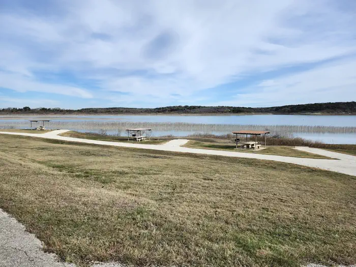
WINKLER PARK
Belton Lake, TX
☆☆☆☆☆0.0(0 reviews)
lake14 sites
Overview Winkler Park is a small, primitive campground on the northern shore of Belton Lake in Central Texas. This park does not have electricity, but does have water hookups at each site, paved back-in sites, and a central water bourne restroom with flush toilets, sinks, and showers. There are 14 sites available for RVs and tents and a day use area. Truly sink into nature in the peaceful park full of wildlife and beautiful sunset/sunrise views! This park is seasonal, and will close Nov 1st - February 28th.Belton Lake was created by the U.S. Army Corps of Engineers with the construction of Belton Dam in 1954. The 12,300-acre lake is located on the Leon River, just upstream of the confluence of the Leon River and the Little River. Belton Lake is a long, narrow and winding lake with many curves and coves, providing some of the best camping, fishing, and boating in Central Texas. Recreation With 136 miles of shoreline, Belton Lake offers a wide variety of recreation activities. Winkler Park is most popular for it's close proximity to the shoreline for campers and fishermen alike and getting back to rustic style camping. The lake is also a popular fishing spot for hybrid striped bass, largemouth bass, white bass, catfish and sunfish. Winkler Park is nestled against the White Flint Wildlife Management Area, which boasts great opportunities for hiking and wildlife viewing and hunting. A short way down the road, campers can visit White Flint Park, which has a day use area that provides a multi-lane boat ramp and courtesy dock. White-tailed deer, hawks, great blue herons, ducks, geese, many species of songbirds, bobwhite quail, Rio Grande turkey, and even an occasional bald eagle visit the lake area, yielding year-round opportunities for wildlife enthusiasts! Facilities Facilities: On-Site Park Hosts/Maintenance Volunteers 14 Campsites (Water ONLY) 1 Water Bourme Restrooms Facility (Flush toilets, sinks, and showers) Day use areaFaciilities Description:Winkler is a beautiful, rural and quaint campground with 14 primitive, sunny sites. Each site has water and a covered picnic table with a grill and fire ring. The park also provides water bourne restrooms with sinks, showers, and flush toilets. Natural Features The campground is fairly isolated on the lake and tucked into the mouth of the Leon River. All sites are lakefront and provide a view of the water/lake. Though the campsites themselves are not shaded, the perimeter of the facility and parts of the shoreline are forested. The lake area is a habitat for deer, wild turkey and water birds such as Great blue herons, ducks, geese, many species of songbirds and even an occasional bald eagle. Nearby Attractions Belton Lake is located adjacent to the Fort Hood Army Base, which has several points of interest for the military buff. The mural painted on the spillway wall of Belton Dam depicts the history of the Bell County area. Contact Info For facility specific information, please call (254) 742-3050.Charges & Cancellations Changes and cancellations are subject to a $10.00 administrative fee. Refund requests are processed through recreation.gov website or app.
ROSY LANE
Grand Mesa, Uncompahgre and Gunnison National Forest, CO
☆☆☆☆☆0.0(0 reviews)
lake23 sites
Overview Rosy Lane Campground is located 17 miles from Gunnison, Colo., in the Taylor River Canyon. Visitors enjoy the area for its rafting, fishing and trail opportunities. Recreation The Taylor River can be accessed from the campground, and offers a calm stretch for rafting and kayaking. Anglers cast for rainbow and brook trout. The Fossil Ridge Wilderness Area is nearby. The Summerville and South Lottis trailheads provide access to the scenic, natural area. A number of off-road trails are found in the surrounding area, including Doctor Park Trail, Taylor River Trail and Taylor Vista Trail. Facilities The campground offers single-family campsites, each equipped with a picnic table and campfire ring. Site 008 has 15-Amp electric hookups. Site 004 is accessible. Campground now has potable drinking water available.Natural Features The campground lies on the banks of the Taylor River, at an elevation of 8,600 feet. Most sites are shaded by a stand of lodgepole pine and aspen trees. Contact Info For facility specific information, please call (928) 537-8888. Nearby Attractions Taylor Park Reservoir is about 12 miles from the campground, with boating, fishing and swimming. A boat ramp and boat rentals are available.
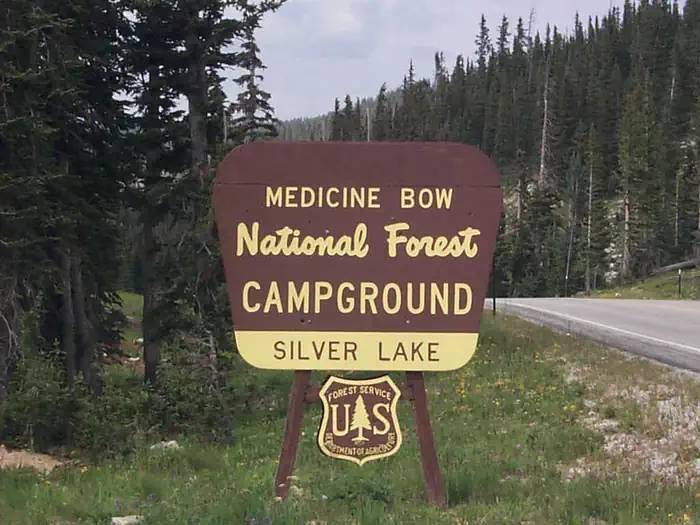
Silver Lake Campground (WY)
Medicine Bow-Routt NFs & Thunder Basin NG, WY
☆☆☆☆☆0.0(0 reviews)
lake17 sites
Overview At just under 10,500 feet Silver Lake Campground is the highest elevation campground on the Brush Creek/Hayden Ranger District. It opens in late June or early July depending on snow depth. The campground is beside the Snowy Range Scenic Byway on Silver Lake. This facility provides easy access to exploring the trails, lakes, streams, and glacial landscapes of the area. Facilities include 17 campsites with 3 RV pull-throughs (trailers under 32'), picnic tables, toilets, water, fire grates, and trash receptacles with a 14 day stay limit. There are two trailheads at the campground. Popular attractions near this campground include Silver Lake, Lake Marie Falls, Mirror Lake, Medicine Bow Peak Trail, French Creek CanyonTrail and Miners Cabin Trail. Recreation The Snowy Range offers endless recreational activities for any kind of visitor. Specifically, the Snowy Range contains a network of hiking trails suitable for day hiking and for extended, backcountry trips. Additionally, Streams and over 100 lakes in the area provide a variety of challenging recreational-fishing opportunities in the area. Popular attractions near this campground include Silver Lake, Lake Marie Falls, Mirror Lake, Medicine Bow Peak Trail, French Creek Canyon Trail and Miners Cabin Trail. Winter activities in the area include snowshoeing and skiing. Mountain Biking Areas for Mountain Biking at Snowy Range Area Bow River Campground Deep Creek Campground French Creek Campground French Creek Canyon Trail Keystone Cabins Lake Owen Trailhead Little Brooklyn Guard Station Little Laramie Trailhead North Fork Campground Pinkham Mountain Trailhead Rock Creek Trailhead Sheep Lake Trailhead Snow Survey Cabin Spruce Mountain Fire Lookout Tie Hack Lower Trailhead Tie Hack Upper Trailhead Tipple Trail Trailhead Mountain Climbing Areas for Mountain Climbing at Snowy Range Area Lewis Lake Picnic Site Libby Lake Picnic Site Day Hiking Areas for Day Hiking at Snowy Range Area Brooklyn Lake Campground Brush Creek Trails Chimney Park Trailhead Corner Mountain Trailhead Crater Lake Trailhead Deep Creek Campground Deep Lake Trail Dipper Lake Trail French Creek Campground French Creek Canyon Trail Green Rock Parking Lot Green Rock Picnic Site Keystone Cabins Lake Owen Trailhead Lakes Trailhead Lewis Lake Picnic Site Libby Lake Picnic Site Little Brooklyn Guard Station Little Laramie Trailhead Meadow Falls Trailhead Miner's Cabin Trailhead North Fork Campground Platte River Wilderness Quealy Lake Trailhead Rock Creek Trailhead Routt Access Trailhead Ryan Park Campground Savage Run Wilderness Sheep Lake Trailhead Silver Lake Campground Silver Lake Trailhead Six Mile Trailhead Snow Survey Cabin South Brush Creek Campground Spruce Mountain Fire Lookout Sugarloaf Campground Tie Hack Lower Trailhead Tie Hack Upper Trailhead Tipple Trail Trailhead West Lake Marie Backpacking Areas for Backpacking at Snowy Range Area Crater Lake Trailhead Deep Lake Trail Dipper Lake Trail Lakes Trailhead Lewis Lake Picnic Site Libby Lake Picnic Site Platte River Wilderness Quealy Lake Trailhead Rock Creek Trailhead Savage Run Wilderness Sheep Lake Trailhead Six Mile Trailhead Viewing Wildlife Areas for Viewing Wildlife at Snowy Range Area Brooklyn Lake Campground Keystone Cabins Libby Flats Observation Site Little Brooklyn Guard Station Snow Survey Cabin Spruce Mountain Fire Lookout Tipple Trail Trailhead Facilities Silver Lake Campground has sites able to accommodate tents, trailers and RVs. Sites are equipped with picnic tables and campfire rings. The campground also offers vault toilets, trash receptacles, and potable water. Natural Features The Snowy Range rises from sagebrush and lodgepole pine forests in lower elevations to spruce-fir forests and alpine areas in the high country. The area offers views of rugged peaks over 12,000 feet, gorgeous snow-melt lakes and stunning displays of native wildflowers. Nearby Attractions Popular attractions near this campground include Silver Lake, Lake Marie Falls, Mirror Lake, Medicine Bow Peak Trail, French Creek Canyon Trail and Miners Cabin Trail. Silver Lake can be acessed using the Silver Lake Trail that surrounds the lake. The lake is 17 acres in size with a maximum water depth of 25 feet. Brook trout reside in the lake. The Snowy Range Scenic Byway is a 29-mile stretch of paved road crosses through spectacular alpine habitats.
GRAHAM CREEK CAMPGROUND
San Juan National Forest, CO
☆☆☆☆☆0.0(0 reviews)
creek24 sites
Overview Graham Creek Campground is situated above Vallecito Lake, in the scenic San Juan National Forest of southwestern Colorado. Visitors enjoy the area for its beautiful scenery and wide range of recreational activities, including boating, fishing and hiking.Recreation Vallecito Lake is a very popular fishing destination, where anglers cast for German brown trout, cutthroat trout, rainbow trout, kokanee salmon and northern pike. The lake offers great boating, water skiing and canoeing opportunities. Boat rentals and fishing licenses are available at various locations around the lake. A variety of hiking and horseback riding trails are found in the area. The North Canyon Trail begins across the road from the campground and leads through ponderosa pine and aspen forests on its way through the canyon. A shorter trail leads to a scenic overlook of the lake. East Creek Trail begins a quarter-mile up Forest Road 852, just northeast of the campground. The trail provides access to a lightly used, scenic drainage where fly-fisherman cast for brook trout. Both trails are popular with horseback riders, however, horses are not allowed in the campground.Facilities The campground offers single-family campsites, a few of which have lake views. Sites are each equipped with a picnic table and campfire ring. Vault toilets and drinking water are provided. The south side of the campground is adjacent to private property.Natural Features Vallecito Lake, Spanish for "little valley," sits at an elevation of 7,900 feet. Scattered ponderosa pine trees tower over the open campground, offering limited shade. Hillside sites are about 100 yards from the high-water line and offer nice lake views. A thick understory provides privacy between sites. Thickets of willow separate the camping area from the lakeshore. Several short trails lead to the lake from the campground. High peaks of the San Juans are visible to the northwest of the campground. Contact Info For facility specific information, please call (661) 702-1420.Charges & Cancellations Cancellations Individual Campsites: Cancellations up to 2 days before a reservation start date incur a $10.00 cancellation fee. A visitor who cancels a reservation the day before or on the day of arrival will pay a $10.00 service fee AND forfeit the first night's use fee including tax and applicable add-on for a campsite. Cancellations for a one-night reservation will forfeit the entire amount paid and will not be subject to an additional service fee. No-Shows A no-show visitor is one who does not arrive at a campground and does not cancel the reservation by check-out time on the day after the scheduled arrival date. Staff will hold a campsite until check-out time on the day following the arrival date. No-shows are assessed $20.00 service fee and forfeit the first night's rate, taxes and applicable add-on for a campsite. Refunds Visitors may submit a refund request through their Recreation.gov profile within 7 days of the end date of their reservation. Refunds will not be issued after the 7 days has ended. Refunds for debit or credit card payments will be issued as a credit to the original bank or credit card used to pay. For check or cash purchases, Recreation.gov will mail a Treasury check for refunds of cash, check, or money order payments to the address associated with the reservation. Treasury check refunds may take up to 6-8 weeks to arrive. In the event of an emergency closure, the Recreation.gov team or facility manager will refund all fees and will attempt to notify you using the contact information within the Recreation.gov visitor profile.
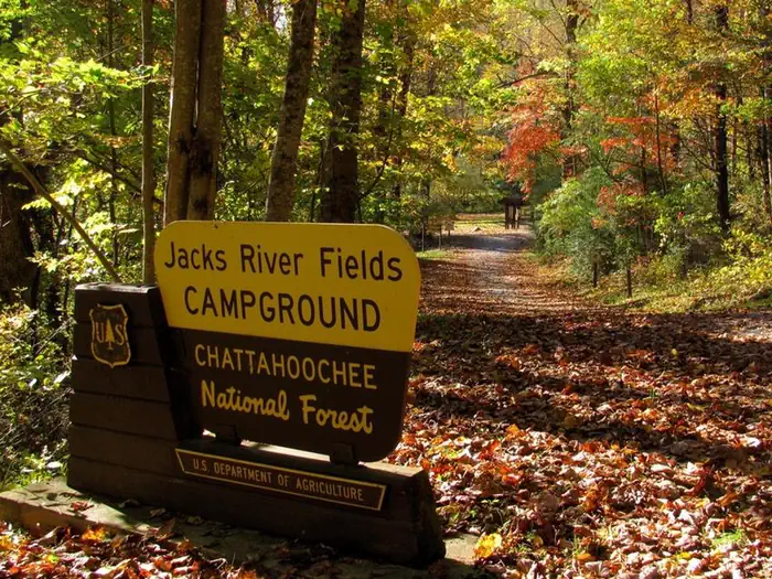
Jacks River Fields Campground
Chattahoochee-Oconee National Forest
☆☆☆☆☆0.0(0 reviews)
creek8 sites
Overview The Jacks River Fields Campground is a seven site campground located in the Blue Ridge Mountains of North Georgia on the Conasauga Ranger District of the Chattahoochee-Oconee National Forest. This campground accomodates horses and mules. This location is available on a first-come, first-served basis only. Visitors are required to physically arrive at the campground to purchase and claim a site. Once on-site, you can pay for your campsite(s) by scanning a QR code using the Recreation.gov mobile app or by following instructions for depositing cash or checks in the fee deposit box. Download the free Recreation.gov mobile app on Android or iOS prior to your arrival as some remote areas have limited or no cellular service. Located along the South Fork of the Jacks River, the Jacks River Fields Campground sits at an elevation of 2700' and surrounded by mixed hardwoods, hemlock, and rhododendron. Wildlife such as bear, deer, and wild turkey can be found in the surrounding forest. Wildflowers are abundant throughout the mountains during spring, summer, and fall. From the late 1800s into the early 1900s this area was a thriving community known as the Upper Jacks River Community, complete with home-sites, a church, and possibly a grist mill. One of those houses was later turned into a Federal game warden station. The game warden was tasked with patrolling the newly established national forest. The community long gone, including the game warden station, visitors can now enjoy a quiet camping experience deep in the mountains. The multi-use South Fork Trail is located adjacent to the campground, allowing for horses, bikes, and hikers. Recreation Hiking and Horseback Riding: This campground is located adjacent to the South Fork Trail, which is a multi-use trail for hiking, biking, and horse riding. The Cohutta Wilderness is nearby and allows for arduous overnight backpacking trips along the Jacks and Conasauga Rivers. Hunting: Hunting for bear, deer, and wild hogs is a long standing fall tradition in the North Georgia Mountains. This campground is located within the Cohutta Wildlife Management Area, a cooperatively managed area between the U.S. Forest Service and the Georgia Department of Natural Resources. The WMA is located completely within the boundaries of the Chattahoochee National Forest. Birding: During spring and summer, songbirds abound. Beginning in early spring, neotropical migrant birds are found traveling from South America and Mexico to their breeding grounds in the Appalachian Mountains from Georgia to Canada, many are only encountered during migration. For many birds, this area is the only place in the Southern Appalachians they breed, making for a unique experience for forest visitors. Wildflowers: The Southern Appalachians are one of the most diverse regions in the world for plants. Many of these plants produce flowers which are brightly colored, luring in pollinators such as native bees, butterflies, and hummingbirds. Other flowers are hidden beneath the leaf litter, unnoticed by the majority of visitors, yet noticed by the beetles that pollinate the unique flowers. These flowers eventually turn into fruits and seeds, feeding birds and small mammals. Facilities Tent pads, parking spurs, picnic tables, fire rings, and lantern posts are provided at each campsite. Bear-Proof trash cans are centrally located in the campground. There is no running water, no electricity, and no dumping station located at this campground. A vault toilet is provided for visitors. A horse trailer day use parking area is located at the back of the recreation area, along with horse corrals and hitching posts. Natural Features Surrounded by forested mountains, the Jacks River Fields Campground is situated in a small hollow in the Blue Ridge Mountains. The South Fork of the Jacks River flows alongside the campground, joining other tributaries, forming the Jacks River. Jacks River meanders through the 45,000 acre Cohutta Wilderness from the southeast to the northwest, joining the Conasauga River near the Tennessee/Georgia state line. The Conasauga River is one of the most diverse rivers in the United States. The Conasauga Watershed contains 76 native fish - more than the Columbia Watershed and Colorado Watershed combined! The geography and elevation changes of the Southern Appalachian Mountains has enabled aquatic species in small watersheds to attain extreme levels of diversity compared to the much larger western watersheds. Salamanders, mussels, snails, crayfish, and other invertebrates show similar levels of diversity. Contact Info This location is unstaffed. To speak with our main office for general information, please call: (706) 695-6736. Nearby Attractions South Fork Trail: The South Fork Trail is located approximately 1/8th of a mile from the Jacks River Fields Campground. This trail meanders through fields and hardwood forests along the banks of the south fork of the Jacks River. One river ford is experienced near the north end of the trail. Be alert, this is a multi-use trail open to equestrians, hikers, and bicycles. Cohutta Wilderness: Located nearby is the 45,000 acre Cohutta/Big Frog Wilderness (the largest Congressaionally designated Wilderness Area located east of the Mississippi River.). The Cohutta Wilderness contains 91 miles of arduous backpacking trails. Horses are allowed on some of the trails in the Wilderness, please contact the Conasauga Ranger Station for more information.
Deadman Campground
Stanislaus National Forest, CA
☆☆☆☆☆0.0(0 reviews)
river0 sites
Deadman Campground is situated along the banks of the Stanislaus River, one mile from Highway 108 on the Kennedy Meadow Road. It is about 29 miles east of the Summit Ranger Station. There are a total of 17 camping sites; two walk-in sites. The main road is paved and parking pads are dirt-surfaced. Restrooms are vault toilets. Water is piped to hydrants serving multiple sites. A fee is charged for extra vehicle parking.
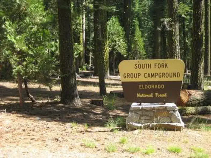
South Fork Group - Eldorado NF (CA)
Eldorado National Forest, CA
☆☆☆☆☆0.0(0 reviews)
river1 sites
Overview South Fork is the largest group campground in the Crystal Basin Recreation Area, nestled in the vast expanse of the Eldorado National Forest. The remote location affords visitors a true outdoor camping experience.Recreation With the South Fork of the Rubicon River located within walking distance, the group camp provides excellent fishing, swimming and other water sports and activities. Facilities While the campground can be used as a single group site that can accommodate up to 125 guests, it can also be reserved as multiple single-family sites. A group cooking area with food preparation tables and double grills is available, as well as campfire rings with grills at each site. Vault toilets are provided, however, drinking water is not available at the campground. Visitors can boil stream water or fill up at nearby boat ramps. A parking area is also available.Natural Features Situated at an elevation of 5,200 feet, the campground sits between the Union Valley Reservoir and Loon Lake. It is also just minutes away from Gerle Creek Reservoir, a serene mountain lake where motorized boating is prohibited in order to preserve a peaceful and quiet atmosphere for visitors. Nearby Attractions Swimming and non-motorized boating are available at Gerle Creek Reservoir, 5 miles north of the campground.
Tombigbee
National Forests in Mississippi, MS
☆☆☆☆☆0.0(0 reviews)
0 sites
The Tombigbee National Forest is located in northeastern Mississippi. Before the establishment of this forest, much of the land was abandoned farmland with rapidly eroding soils. Its rolling hills are now covered with pine and hardwood forests. They are rich with wildlife and intermingled with private farms and woodlots. National Forest system lands on this forest is scattered across numerous counties.
Seafoam, Marsh Cr., Langer & Soldier Area (MF3)
Salmon-Challis National Forest, ID
☆☆☆☆☆0.0(0 reviews)
0 sites
This area encompasses trails, trailheads, camping and other recreation sites that are generally accessed from the Seafoam area on the Middle Fork Ranger District. The Seafoam “bubble” is non-wilderness and contains the Josephus Campground and trailhead for the Soldier Lakes area. Be aware of the Wilderness boundaries.
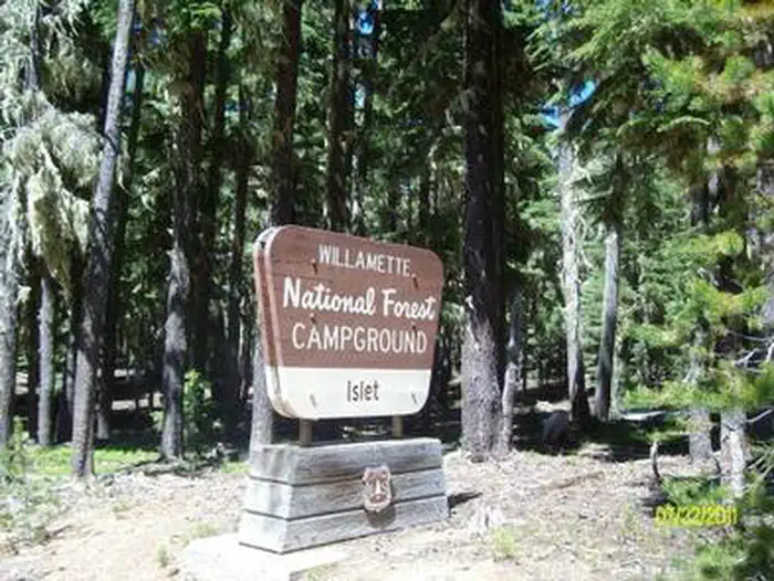
ISLET CAMPGROUND
Willamette National Forest, OR
☆☆☆☆☆0.0(0 reviews)
lake33 sites
Overview Waldo Lake is one of the largest natural lakes in Oregon. It offers a uniquely peaceful setting on the water and along remote shorelines, surrounded by forests of Douglas fir and mountain hemlock. Recreation in the area is abundant with the lake an ideal location for water activities like sailing, canoeing and swimming.Recreation Waldo Lake is circled by the Jim Weaver Loop, 22 miles of trail for hiking and biking. Bikes are allowed on the trails, but not in the nearby Waldo Lake Wilderness. There is also easy access to the Pacific Crest Trail.Facilities This 55 site campground is located at the north end of Waldo Lake, just south of North Waldo Campground, 31 sites are reservable. Each site has a fire ring and picnic table. There are three vault restrooms within the campground and another at the boat launch/day use area. Islet offers wonderful sandy beaches. Western winds consistently blow each afternoon, offering respite from early season mosquitoes, which are typically intense from June to mid-August so come prepared.Natural Features Situated high on the western slopes of the Oregon Cascades at 5,400 feet in elevation, Waldo Lake is one of the purest lakes in Oregon (9.8 square miles with a maximum depth of 427 feet). It has no permanent inlet to bring nutrients into the lake for plant growth. The lack of plant life contributes to its purity, allowing you to see to depths of 120 feet on a calm day. Nearby Attractions The north end of Waldo Lake is a popular starting point for many wilderness trails and lakes, most notably the Rigdon, Wahanna and Torrey Lakes. The 1-mile Shoreline Trail between Islet and North Waldo campgrounds provides a short and pleasant hike along the lakeshore.